Digital Maps
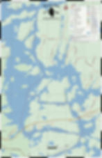
Maps are in 1:20,000 scale and available in JPG, PDF, and GeoTIFF format. Start by viewing the Index Maps to find the trail or specific section to download.
Questions? Our F.A.Q. section has some answers.
.jpg)
West
.jpg)
East

Plan Your Trip
As you continue to explore the wonders of Path of the Paddle across Northwestern Ontario, we are excited to introduce a new addition to our map collection – digital maps! In addition to our existing physical Overview Route Map, we are now offering digital versions of our maps that can be accessed from anywhere, at any time, through your smartphone, tablet, or your preferred mapping device. Our digital maps provide a more interactive experience, allowing you to zoom in and out, mark your favourite spots, and plan your route more efficiently.
These digital maps at 1:20,000 scale are available in three common formats: JPG, PDF, and GeoTIFF, making it easy for you to view them on your preferred device. With the added convenience of digital maps, you can easily access them on the go and plan your paddling adventure with ease. We are confident that this new offering will enhance your paddling experience and help you discover even more of Path of the Paddle.


Thank You!
Our goal is for Path of the Paddle to be accessible by everyone, and have created these maps with this goal in mind.
Help support our mission by including a small donation with your downloads: